British-Irish Ice Sheet

British-Irish Ice Sheet
Ice sheet in Northern Europe during the Pleistocene Ice Age.
No account needed. By playing, you confirm you're 13 or older and agree to the Terms of use.
No owners yet
Category: Empty
- 0 owners
- 0 copies
- 0 pulls
- Wishlisted
- 0
- In 0 albums
- On 0 showcases
- Market listings
- 0
Not sold on the market yet.
Readers' pathsAug 2026 – Oct 2026
Readers go next to
Share of the 226 clicks on its links


Readers come from
Share of the 476 readers arriving from another article

St Patrick's Bridge
Intertidal elongated landform in Ireland.
39%

Ice age
Period of long-term reduction in temperature of Earth's surface and atmosphere.
19%

Stonehenge
Prehistoric monument in England.
14%

Isles of Scilly
Group of islands in Cornwall, England.
11%

Lake Flixton
Prehistoric lake in North Yorkshire.
8.4%
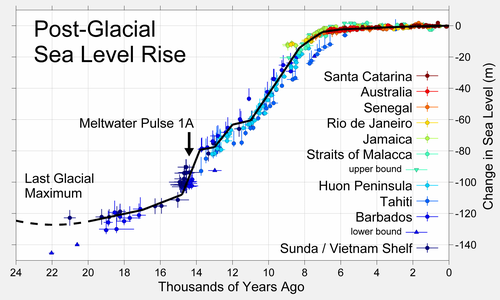
Early Holocene sea level rise
Sea level rise between 12,000 and 7,000 years ago.
3.2%

Doggerland
Former landmass in Northern Europe.
2.7%
Glaciology
Scientific study of ice and natural phenomena involving ice.
2.5%